Meeting and King Streets, the main thoroughfares running down the center of the Charleston peninsula southward from White Point Garden, are home to several historic city parks- Washington Square, Marion Square, Wragg Square, and Wragg Mall- with colonial and Federal-era origins and which were all overhauled in the late nineteenth century into the popular recreational spaces that visitors and locals enjoy still today.
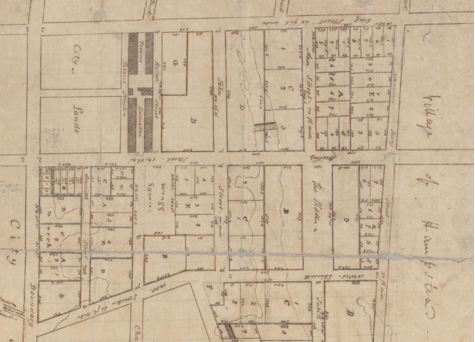
![“City Lands” (Marion Square), Wragg Square, and “The [Wragg] Mall” in 1789. McCrady plat.](https://charlestonempireproperties.com/wp-content/uploads/2021/04/blog1.png)
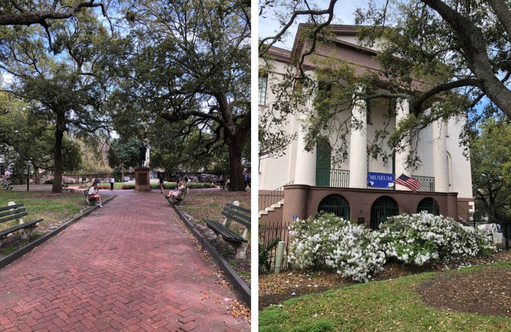
The square was first opened in 1818 and acted as a greenspace buffer between the Fireproof Building, functioning as a sort of fire break from neighboring houses, as well as a park. It was in a state of neglect in 1881, when Mayor Ashmead Courtenay had it renovated and dedicated as Washington Square, in honor of the future first president’s victory at Yorktown 100 years earlier.
The focal point in the center of the park is an obelisk for Washington, and there are monuments to poet Henry Timrod and confederate general PGT Beauregard on the periphery. The 1.5-acre park’s walkways are lined with Battery benches under live oak canopies.
The city proudly reported the following year, “what has been known as city square, and by other indefinite names, was changed from its somber and uninviting appearance into a modern park, with fountains, walks, sofas, and the most beautiful growth of grass seen anywhere in the city. Perhaps nothing can be more in contrast than the old and new square- formerly dismal and uninviting, with scarce a single visitor any day, now bright and cheerful, much frequented, and at certain hours of the day crowded with children.” It remains a popular verdant oasis in the heart of the city center today.
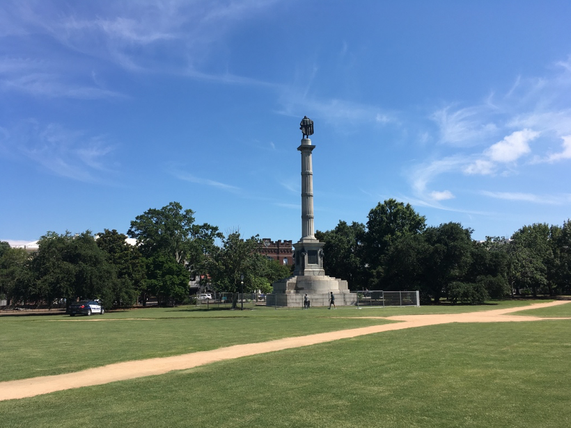
Several blocks northward and bounded by Calhoun, Meeting, King, and Tobacco Streets is Marion Square, a large 6.5 acre green punctuated with sand walkways and historic monuments. The square hosts Charleston Wine+Food Festival, Fashion Week, Southeastern Wildlife Exposition, and a weekly farmers market in addition to being a favorite sunbathing and lunch picnic spot.
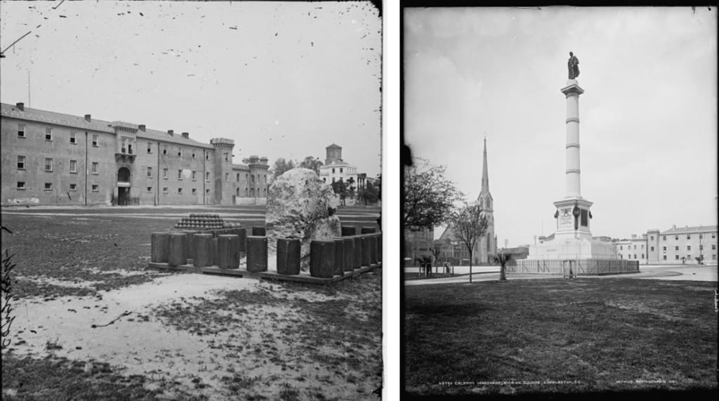
Historically, it was the site of the large tabby (oyster shell concrete) fortification ever built in the American South. This “hornwork” was constructed in the 1750s to protect Charlestown from land invasion, but it fell to a British invasion during the American Revolution in 1780. A small chunk of what was once a fortress covering four acres still sits in the Square today, to commemorate the site’s military history.
The state purchased the northern side of the fort site in 1789, “for the purpose of erecting a warehouse for the reception and inspection of tobacco”, which is the origin of the name of the pedestrian lane called Tobacco Street.
Despite being a city park, Marion Square is actually owned by the Washington Light Infantry and Sumter Guards, and it has functioned as a military parade ground for the state arsenal and various militia groups for much of its life. Historian Nic Butler explains that in 1883, “After months of negotiations, the City Council of Charleston entered into a landmark real estate agreement with the Field Officers of the Fourth (or Charleston) Brigade of the South Carolina Militia. According to their agreement, the city of Charleston transferred to the militia the ownership of a six-acre rectangle of land bounded by King, Calhoun, Meeting, and Tobacco Streets, in front of the Municipal Guard House. The city conveyed this land to the Field Officers of the Fourth Brigade in trust.”
In 1843, the Citadel Academy opened in the large castellated masonry building on the northern edge of the square. It was created in response to white Charlestonians’ domestic fears in the wake of the failed Denmark Vesey slave insurrection of 1822; the young cadets would be trained to quell any local violent outbreaks, along with the military groups who paraded on the square.
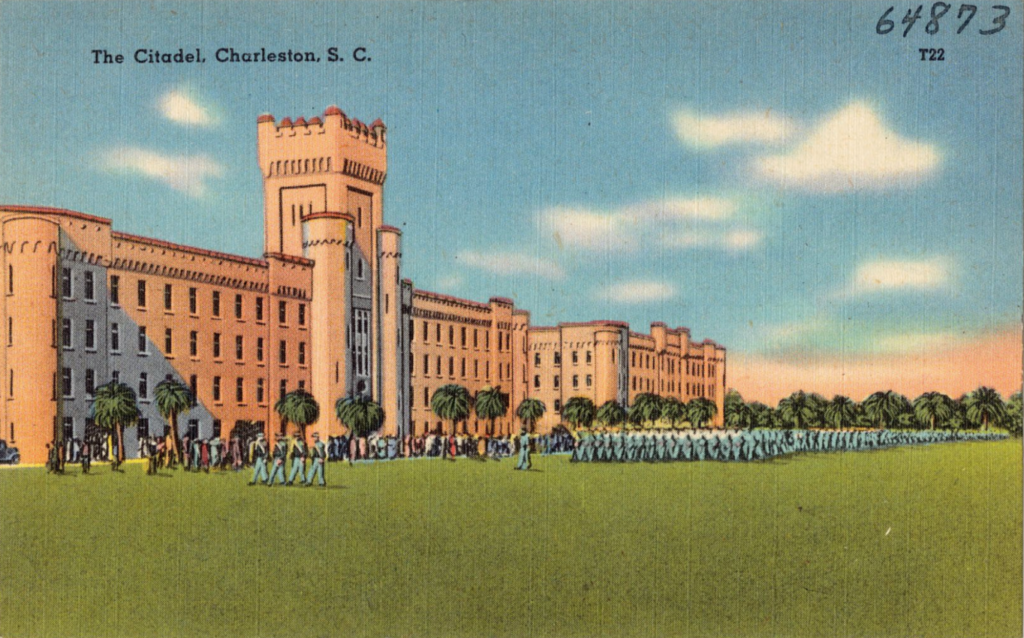
The Union Army occupied the building during Reconstruction, while local baseball teams played pitched games in Marion Square that more than once led to a sports and race riot, which the army quelled. The shell pink former Citadel is now the Embassy Suites hotel (next to the brand-new, posh and popular Hotel Bennett.)
Mayor Courtenay took the recommendations of the Pleasure Grounds Commission in 1882 to refurbish the parade ground as a proper city park, and formally adopted the Marion Square name that year. They razed several buildings along the edges of the park and re-landscaped, adding artesian wells, fountains, and memorials.
Marion Square has been in the news recently because of the political lightening rod John C. Calhoun Monument, which was erected in 1887 and taken down in 2020. As early as 1915, City Council lamented the unpopularity of the statue; “it is to be noted in this connection that this handsome monument is being subjected to abuses which ought to be stopped, and the commissioners recommend putting up two extra lights on the square in close proximity to the Monument.” The removal gave archeologists the chance to open a time capsule hidden in the granite base of the monument that held a lock of Calhoun’s hair and a banner from his 1850 funeral.
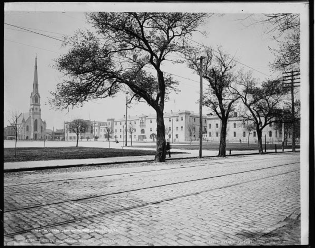
Every Christmas, the city erects an iconic multi-story light tree at the center of the Marion Square and illuminates the oaks and palmetto trees that line the periphery, and St. Mathews German Lutheran Church and Citadel Square Baptist Church across from the square (both dating to the 1850s and featuring some of the tallest spires in the city) adorn wreaths and decorations for the holiday season.
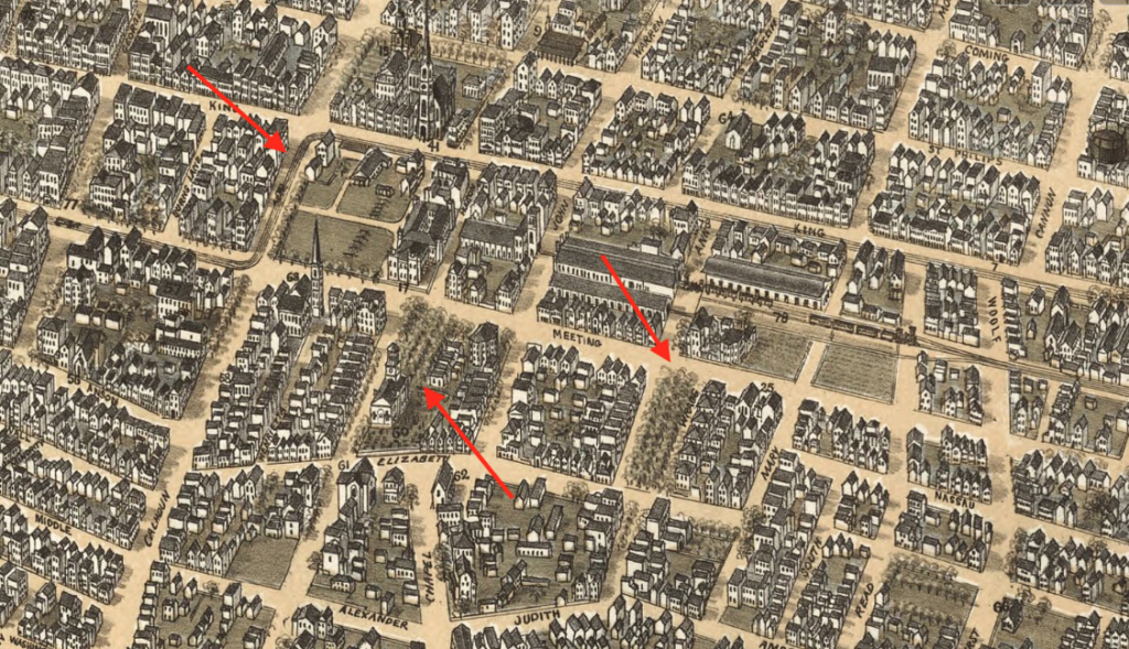
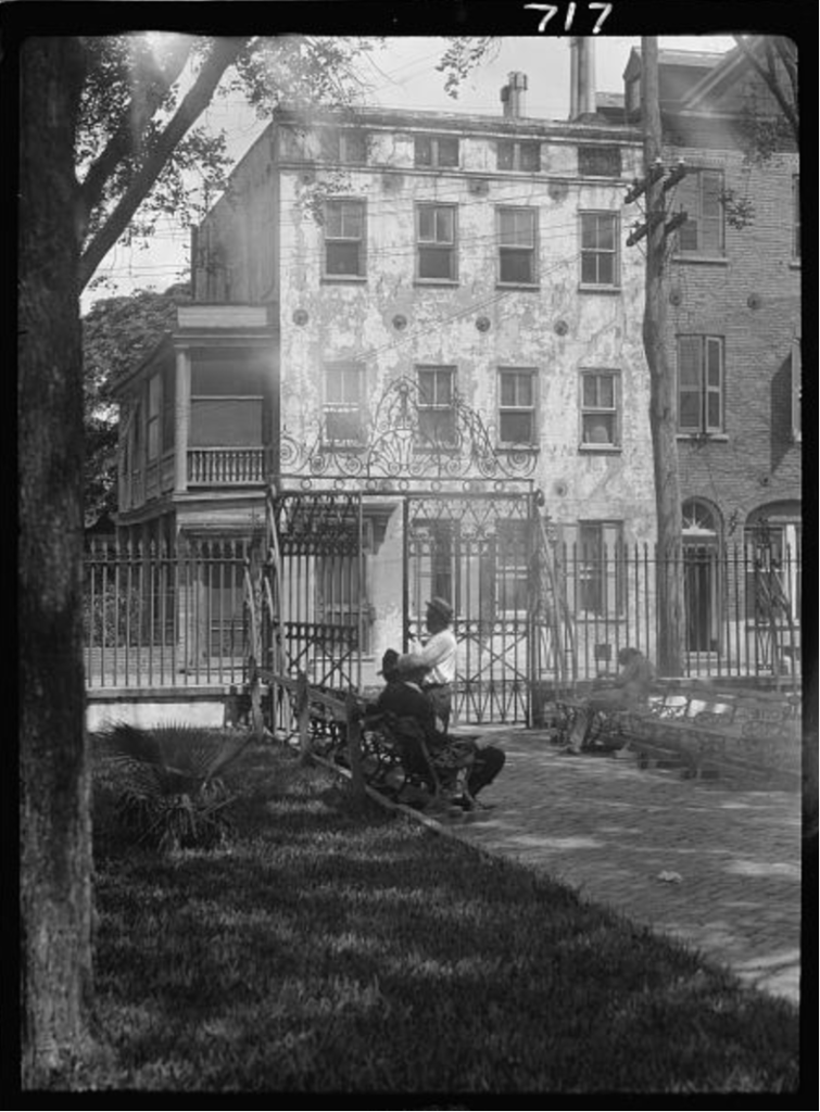
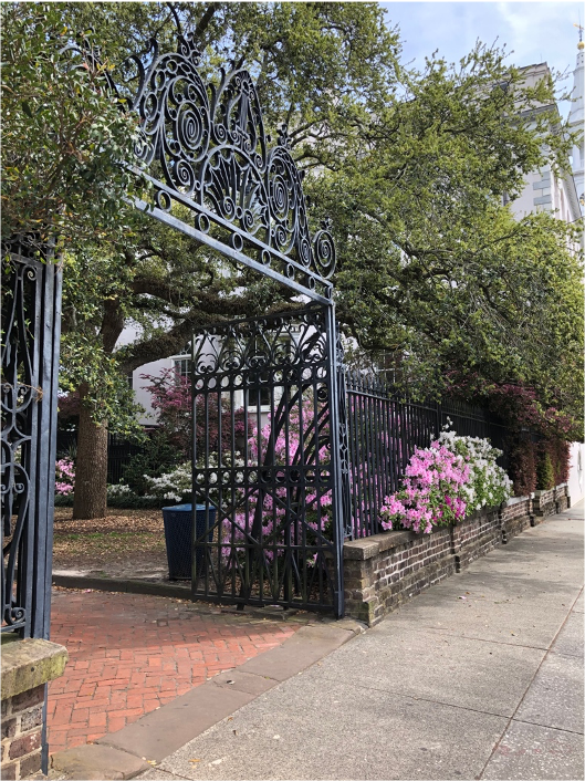
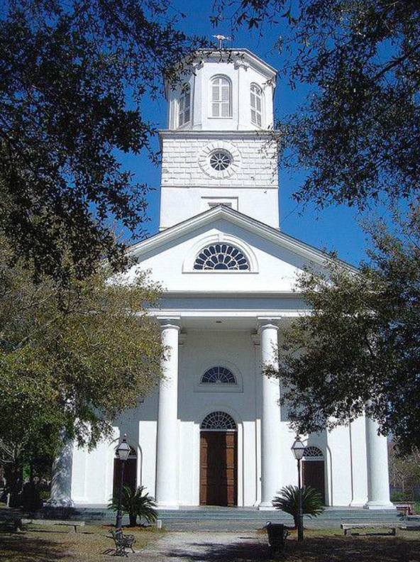
Across Meeting Street just one block north is the Wragg Square (also called Ashmead Place), a hidden gem of a tree-lined, elevated garden in the shadow of beautiful Second Presbyterian Church, a large neoclassical building with a temple front and tall belltower, built by the Gordon Brothers in the 1810s. The square appears on some historic maps as “Flynn’s”, for an early pastor of the church. City Council formally named it Wragg Square in 1881.
Marion Square, Wragg Square and Wragg Mall, which is two blocks north on Meeting Street, are all located on land that was outside the town limits and owned by the Wragg family in the eighteenth century. The Wraggs subdivided and created surrounding Wraggborough neighborhood and donated the land to the city to create the eponymous two greenspaces. A writer noted in 1889, that, “the iron memorial tablets at the entrance to Wragg Square and Wragg Mall, placed there by city council, to record the thoughtful kindness of Major John Wragg, will transmit to future generations the name Wraggboro [sic].”
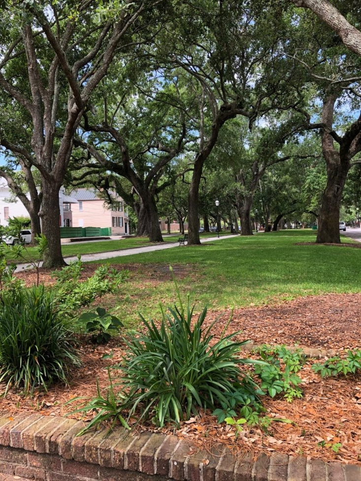
The Mall is a narrow park bounded by Meeting, Elizabeth, Ann, and Wragg Streets, with a shell path lines with trees and benches, and a historic cast iron fountain in the center. It’s a popular place for neighborhood dogs and for lunch breaks. There are two brick 1850s houses on the northern edge that are all that remains of Aiken’s Row, which once included seven large residences. They were constructed by the Aiken family (who owned the stately Aiken Rhett house at the end of the Mall which is now a house museum run by Historic Charleston Foundation). Locals once called them the “Seven Wages”, based on a legend that the tenancy from each house could fund the operation of the Aiken mansion for one day of the week. Charleston Museum and several quaint Victorian houses line the other side of the Wragg Mall.
What have you discovered while exploring Charleston’s middle peninsula parks?
Sources:
- Library of Congress photograph collection
- McCrady plat collection, Charleston Register of Deeds
- Ethan Kytle and Blain Roberts. Denmark Vesey’s Garden: Slavery and Memory in the Cradle of the Confederacy. The New Press, 2018.
- “The City Square”. News and Courier. Charleston, South Carolina. April 1, 1881. p. 4.
- “Washington Square”.Charleston News & Courier. January 1, 1891. p. 8. Retrieved Nov 20, 2012.
- Nicholas Butler. “Rise of the Horn Work.” June 2020. Walled City Task Force. https://walledcitytaskforce.org/2020/06/17/the-rise-of-charlestons-horn-work-part-2/
- Charleston Parks Conservancy. “Marion Square.” https://www.charlestonparksconservancy.org/park/marion-square
- National Park Service. “Marion Square.” https://www.nps.gov/places/marion-square.htm
- Nicholas Butler. “Marion Square Part 1.” Charleston Time Machine. https://www.ccpl.org/charleston-time-machine/brief-history-marion-square-part-1
- Nicholas Butler. “Marion Square Part 2.” Charleston Time Machine. https://www.ccpl.org/charleston-time-machine/brief-history-marion-square-part-2
- https://charlestonempireproperties.com/mazyck-wraggborough-charlestons-garden-district-neighborhood/
- City of Charleston. Charleston Yearbooks, 1881, 1883, 1910, 1915. Charlesotn: Walker and Evans Press.
- Archer, Henry Purse. Local Reminiscences: A Lecture delivered before the Mutual Aid Association, 1889. Charleston: WECCO, 1893.
- City of Charleston. General Ordinances of the City Council of Charleston, 1895.
- Christina R. Butler. Lowcountry at High Tide. Columbia: University of South Carolina Press, 2020.
- Jonathan Poston. Buildings of Charleston. Columbia: USC Press, 1996.

 CALL US
 EMAIL US