Just outside of the touristy, better known part of Charleston is the large expanse of the upper peninsula’s west side, which is home to several beautiful parks in the midst of historic residential neighborhoods. Each offers unique amenities; Hampton Park, the largest and oldest, features reflecting ponds, historic monuments, athletic fields, and walking and cycling trails along a colonial-era former racetrack. Allan Park, the smallest, offers places to sit and visit with neighbors in the shade of live oak trees. Furthest to the north, Corrine Jones Park offers athletic fields, a playground, and a community garden. All of these green spaces are located on the Charleston Neck, a historic catch-all term for the narrow land on the peninsula outside the original town boundaries, on former plantation lands. Charleston’s West Side parks were made possible as the land transitioned to small farms and then to several new suburban developments at the turn of the twentieth century.
Allan Park lies on the southern edge of Hampton Park Terrace neighborhood and is bounded by Ashley Avenue, Glenwood Drive, and North and South Allan Streets. The land was once part of Pick Pocket Plantation, just to the south of the Grove/Lowndes Grove plantation. In the colonial era, William George Freeman owned the land and gave it its unique name. During the War of 1812, the American forces built a line of fortifications through the area (this is the origin of Line Street, and there were fortifications near Ashley Avenue as well.)
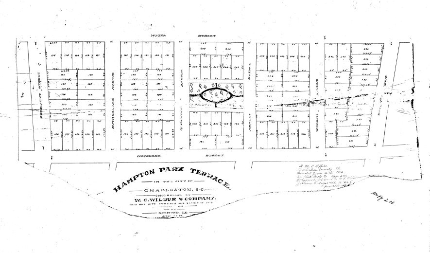
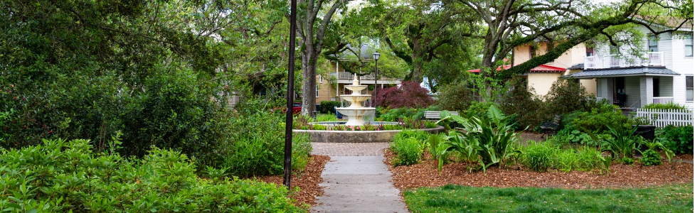
The park is named for the Allan family; James Allan helped develop a quadrant of the Hampton Park Terrace neighborhood and his widow Amey Allen donated the land for the small park to the city in 1920. The concept for the small park, however, was included in the original concept plan for Terrace, which was drawn in 1912. The neighborhood experienced a building boom from 1915 into the early 1930s, and Allan Park is framed by craftsman cottages and wood frame bungalows that were popular in that era. The park has pathways that converge from its four corners on a focal point cast-stone fountain that was installed in the early 2000s to replace an earlier one.
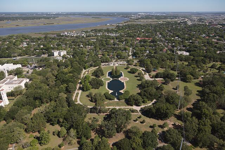
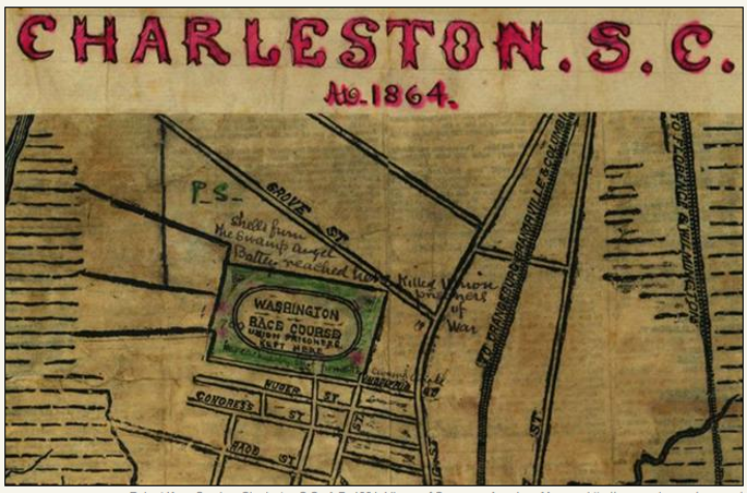
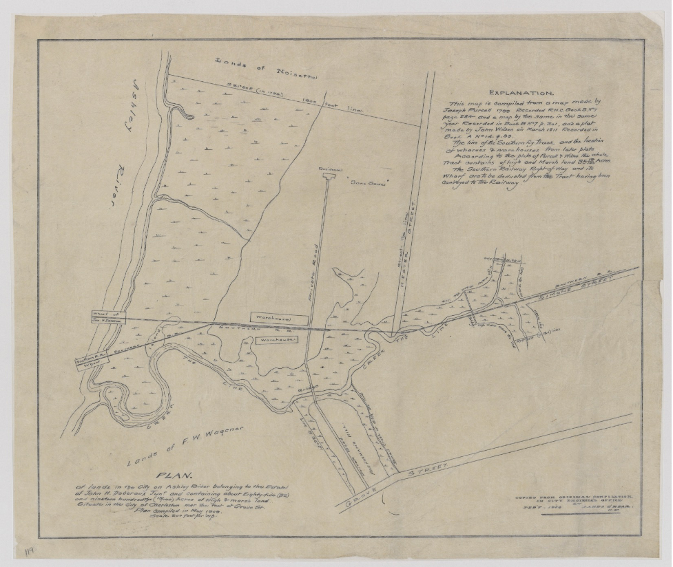
Hampton Park is the largest greenspace in urban Charleston and is the jewel of the Hampton Park Terrace neighborhood. The land was owned by James Gibbes in the 1770s and was part of the Lowndes Grove Plantation. The South Carolina Jockey Club acquired part of the tract and created the Washington Course, a mile-long horse racing track which operated from 1794 until circa 1882. During the American Civil War, the oval track became a prisoner of war camp and mass burial ground for Union soldiers, and the site of the first Memorial Day celebration in the nation’s history, in 1866.
There is a monument in Hampton Park today to commemorate its war time history, but that heritage was mostly forgotten by the turn of the twentieth century, when the former racetrack and neighboring Wagener’s Farm (donated by its namesake Captain Frederick W. Wagener, who owned historic Lowndes Grove at that time) were transformed into the fairgrounds for the 1901 South Carolina Interstate and East Indian Exposition. The Exposition was a World’s Fair style year-long event designed to showcase Charleston’s amenities and boost the economy by enticing new businesses and tourists, and it attracted hundreds of thousands of visitors between 1901 and its closing in 1902. The 250-acre fairgrounds featured a master plan by architect Bradford L. Gilbert with a Women’s Building, Negro Building, structures for state displays, a “Court of Palaces” at the center of the site, concession stands, and theme villages.
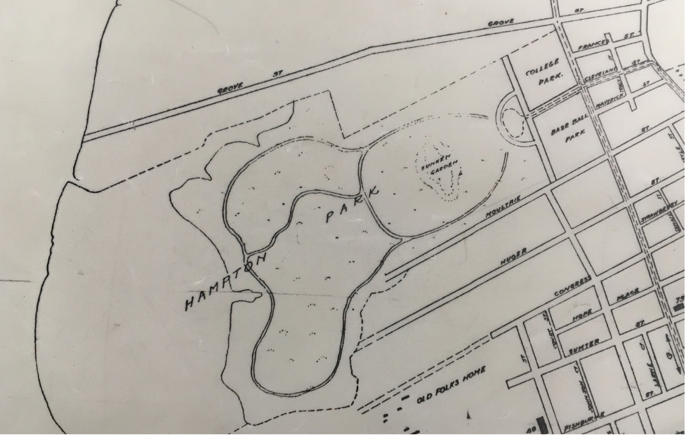
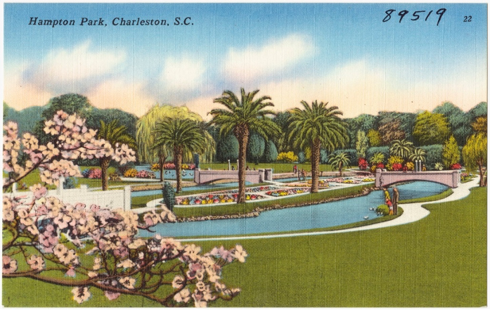
The fairgrounds and its midway form the bones of today’s Hampton Park; the City of Charleston purchased the site and hired Olmsted Brothers Landscape Architects to convert it into a park. The sunken gardens, a colonial revival “inn” building on Mary Murray Drive, and the bandstand in the park today are vestiges of the fairgrounds that were incorporated into the new plan. The sunken gardens have been converted into reflecting ponds that are a favorite with children who come to feed the local ducks and geese that live on the center “island”.
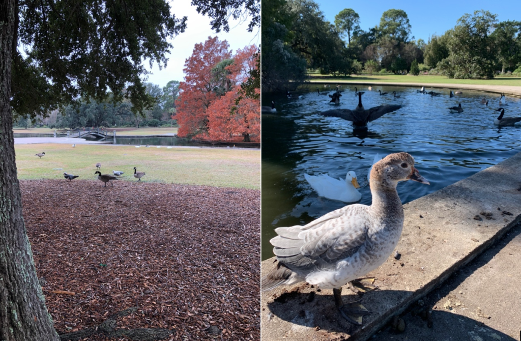
Hampton Park features miles of oak-lined walking trails amidst planting beds that are kept brimming with beautiful native plants and flowers by the Charleston Parks Conservancy. The Preservation Society notes that, “the oval track of the Washington Race Course remains as the bed of Mary Murray Drive, which encloses Hampton Park. The road was improved and paved in 1924, with funding by philanthropist Andrew Buist Murray, and named in memory of his wife, Mary Hayes Bennett. Simple stuccoed gateposts stand at the Cleveland Street entrance to the park.” The oval track remains popular for joggers and cyclists. The east end of the park along Rutledge Avenue has a baseball pitch and a large, multi-purpose athletic field that local soccer players and the Charleston Hurling team use for their scrimmages.
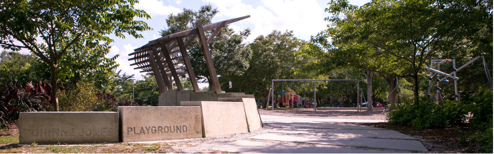
Further north, Corrine Jones Park is a hidden gem situated on the western edge of Wagener Terrace and North Central neighborhoods, near the Ashley River. The area was part of Sans Souci Plantation in the colonial era, owned by Robert Williams before it passed to Arthur DeBardeleben, a Hessian soldier, in 1781. Sans Souci became a series of smaller “country seats” or farms with residences that were owned by Louis Dunneman and J.H. Devereux in the late nineteenth century (they are the namesakes of two streets in today’s Wagener Terrace.) Once Wagener Terrace was created, Charlestonians purchased the medium sized residential lots and filled them with cottages, colonial revival houses, and some small duplexes.
During World War Two, the future park site at the river-end of Waggener Terrace was home to temporary work force housing built by the Ashley Homes Company, which was demolished in the 1950s when the Charleston County School District bought the land. The park was originally known as Hester Park because it bounds on Hester Street but was later renamed in honor of Corrine Jones, an African American community leader who served as the City Superintendent of Playgrounds in the 1930s. In 2011 the City of Charleston appropriated the land and renovated it as a city green space. The park today has a small athletic field, tennis courts, a recently updated playground, and a community garden with a pavilion created in a partnership between the Charleston Parks Conservancy, Speedwell Foundation, and the Clemson Architecture School, whose students helped construct the facility. Thanks to the Charleston Digital Corridor Foundation, park goers enjoy free Wi-fi.
All three of these City of Charleston’s west side parks are beautifully maintained today and feature nearby on street or lot parking free of charge. They are in walking distance of the historic neighborhoods where they are located and are accessed by tree lined sidewalks for pedestrians and children on bicycles. Whether you’re interested in jogging, feeding ducks, sports fields, or sitting on a quiet, shaded bench or having a picnic, Hampton Park, Corrine Jones, and Allan Park will not disappoint.
Sources:
– Clemson Architecture and Community Build. “Who was Corrine Jones? Good Question.” https://caccstudiov.com/2011/09/02/who-is-corinne-jones-good-question/ February 2011.
– Charleston Parks Conservancy. “Corrine Jones Park.” https://www.charlestonparksconservancy.org/park/corrine-jones-park
– Post and Courier, “A Charleston Park got a garden structure. Clemson students got ‘real world experience’”, 26 April 2019.
– Charleston County Public Library. Vertical files. Parks: Hampton Park, Corrine Jones Park, Allan Park.
– Christina Butler. Lowcountry At High Tide. USC Press, 2020.
– Kevin Eberle. A History of Charleston’s Hampton Park. Charleston: History Press, 2012.
– National Register nomination, Hampton Park Terrace, 1997.
– Historic maps and plats
– Preservation Society, Halsey Map, “Sunken Gardens”, “Washington Race Course”. www.halseymap.com
– Christina Butler for Charleston Empire Properties. “Where It’s At: Wagener Terrace.” https://charlestonempireproperties.com/where-its-at-wagener-terrace/. February 2020.
– Christina Butler for Charleston Empire Properties. “Hampton Park Terrace: Charleston’s City Beautiful Neighborhood.” https://charlestonempireproperties.com/hampton-park-terrace/. December 2019.
– Chibbaro, Anthony. The Charleston Exposition. Charleston: Arcadia Publishing, 2001.

 CALL US
 EMAIL US